Request Demo

Gridics Identifies 6 Ideal Sites For Amazon HQ2 Campus in Miami

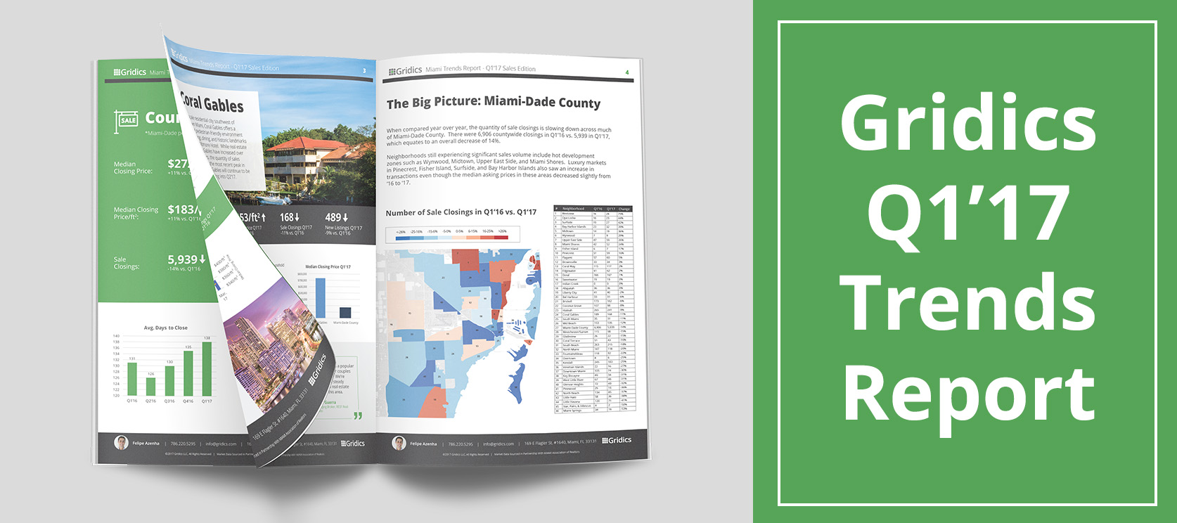
Using Gridics to Analyze Government-Owned Vacant Land Suitable for Amazon

On September 7, 2017, Amazon published a Request For Proposals (RFP) for cities interested in becoming the home of its next headquarters campus.

Amazon’s RFP spells out specific quantitative real estate requirements and qualitative market requirements such as square footage needed, proximity to transportation, and zoning conditions.  It turns out, this kind of detailed analysis is exactly what the Gridics application is designed to automate.

Instead of taking weeks using traditional methods, Gridics produced the precise report within hours.  Our full comprehensive real estate zoning and development analysis report highlighting the viable development sites for Amazon’s potential second heaquarters can be found here.

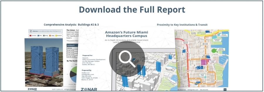
www.zonar.city/case-study/Amazon-Headquarters

How We Conducted the Analysis

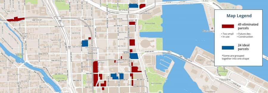
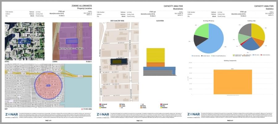
We used Gridics to narrow the search from 150 parcels to six sites in Miami’s downtown urban core that would allow Amazon to develop a mixture of high rise office and mixed use buildings to meet their needs while staying within the as-of-right zoning regulations.  Each site is near the Metromover public transportation stops, which allows employees to move easily between buildings.

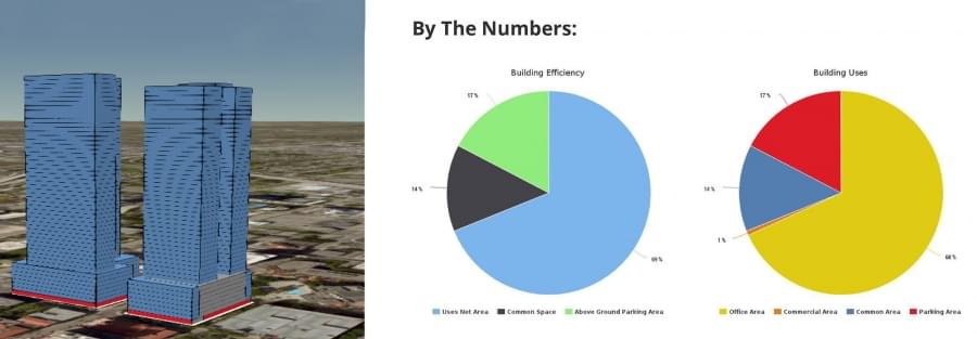
The published report has sections outlining the Amazon RFP, how the sites were identified, a 3-D volumetric massing of each building with full considerations of use type, parking requirements, lot coverage, setbacks and LEED bonuses for environmental friendly development.  The in-depth report showcases six building sites with varying structure types ranging from dedicated office buildings with first floor retail as well as full mixed use options that would allow Amazon to incorporate a hotel and even some residential with the office space.

“Making sense of information from disparate data sources and giving users a real-time, 3-D image of what’s possible from a zoning perspective is exactly why we built the Gridics application,” says CEO Jason Doyle.  “Building on early partnerships with cities, we are now expanding to major metros and are excited to bring 21st century functionality to the historically frustrating and opaque zoning process.”

What’s Next / Ways to Learn More About the Report

In addition to downloading the full report, we’re hosting a free open webinar on Thursday, October 5th at 1pm EDT to answer questions and showcase how we used the technology.

To register, please visit http://amazonreports.zonar.city.

The Gridics Advantage

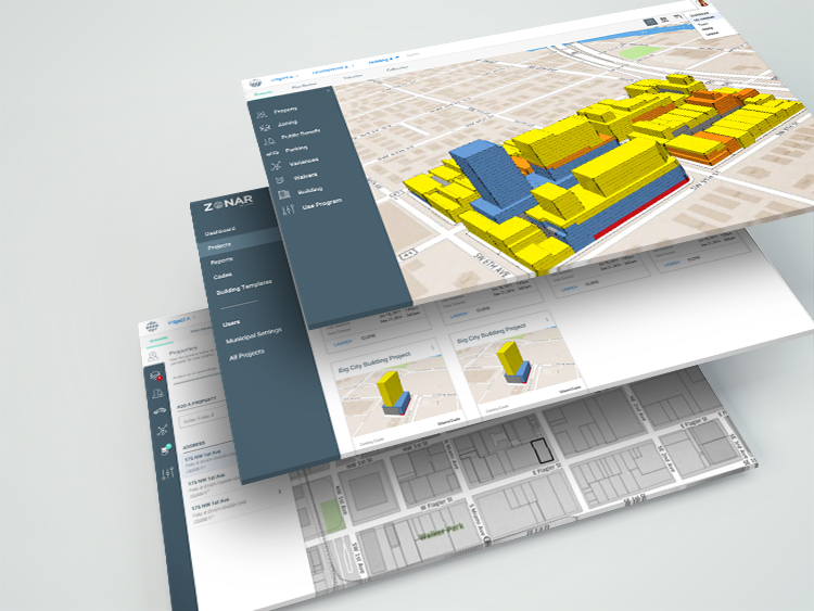
Gridics has a proprietary rules-based engine that integrates the regulations and variables of a zoning code with property records, GIS parcels shapes and zones to allow users to create real-time, 3-D development scenarios on a map interface.  Once a city’s zoning code is integrated into the Gridics platform, users ranging from municipal planning and zoning departments, real estate developers, architects and brokers can run similar analyses with unlimited variations in minutes.  Without Gridics, this process is manual, takes weeks, costs thousands of dollars and is restricted in terms of creating variable scenarios.  Cities are beginning to adopt Gridics’ automated code compliance function to more quickly assess incoming development plans and applications.

About Gridics: Headquartered in Miami, FL, Gridics is a technology company developing software as a service (SaaS) products for the real estate marketplace including their digital zoning platform.

For more information, visit www.zonar.city or www.gridics.com.

How Land Use Attorneys Are Streamlining Feasibility Studies With 3D Tech

For years, zoning feasibility studies have been cumbersome and low-value (but necessary) work for the real estate community.  Thanks to 3D technology and digitized zoning codes, Gridics is on a mission to change the way land use attorneys conduct zoning reports once and for all.

It is now possible to run a feasibility report with just a few clicks of your mouse.  Major S. Florida law firms like Akerman, Gunster, and Shutts & Bowen, along with the City of Miami, are already using Gridics in their land use practices, and we encourage the rest of the Miami legal community to explore the benefits of the platform as well.

Join us on Tuesday, July 25th for a webinar to discuss the future of 3D zoning reports and the ways Gridics can streamline your Land Use & Real Estate practice.

RSVP here:  http://discover.zonar.city

Sample feasibility report:

Big Data: How a SaaS Startup is Disrupting Zoning and the Future Development of Cities

According to a recent study by the United Nations 54 percent of the world’s population lives in urban areas and this trend is expected to increase to 66 percent by 2050. Projections show that urbanization combined with the overall growth of the world’s population could add another 2.5 billion people to urban populations by 2050.

Cities need to start planning for this growth today. Does your city want to become more walkable and less reliant on automobiles?  Does your city want to encourage transit-oriented development (TOD) and other sustainable practices? The most valuable tool that a city has to achieve its vision for future development is its zoning code.

What is zoning?

Zoning is a term for an often vast and complicated set of rules and regulations that determine what and where you can build and what activities you can engage in on a property.  In laymen’s terms, zoning sets the rules of the game for real estate development and has a significant impact on city’s future development patterns.

Zoning is derived from the practice of designating mapped zones, which regulate the use, form, design and compatibility of development. There are a great variety of zoning types, some of which focus on regulating building form and the relation of buildings to the street with mixed-uses, known as form-based, others with separating land uses, known as use-based or a combination thereof.

The most basic elements of zoning include:

  • Height
  • Setbacks (how far from the property line your building can be)
  • Lot coverage (how much of your land can be used for buildings)
  • Uses

Cities draw the playing field. They set the regulations and are in charge of amending, proposing and managing changes to the code. The main objective of codes, however, is to organize growth.

Zoning is complicated, but it shouldn’t be

Understanding the zoning of a parcel and what can be developed is difficult and usually involves hiring a land use attorney or architect, several thousand dollars and can take weeks. Land use attorneys and architects are familiar with what is often a 500+ page PDF zoning document.  They also have knowledge of all the nuances, rules, and amendments related to particular zones that can have a dramatic impact on the development potential of a site.However, their expertise is generally limited to no more than a handful of zoning codes. Experience in one particular zoning code does not guarantee that they can “breeze” through the next zoning code. Every city’s zoning code is different, in some cases drastically different.

Disrupting zoning

At Gridics, we developed a patent pending zoning software that at its core allows city planners to write, test, visualize and update zoning codes in real time.  In simple terms Gridics combines GIS zoning layers and parcel shapes with a city’s zoning code. We’re essentially digitizing and automating zoning codes as well as bridging the gap between the public and private sectors.

The result is that property owners and real estate professionals can click on a parcel or assemblage and quickly understand the development potential of a site in 3D. A process that normally costs thousands of dollars and weeks of analysis can now be completed with a few clicks.

How Gridics Helps Cities?

By taking advantage of our software capabilities, urban planners can:

  • Visualize 3D building envelopes in real time
  • Analyze 3D allocation scenarios (parking, common spaces, etc.)
  • Perform weeks of zoning capacity calculations in minutes
  • Test new zoning scenarios to improve development patterns
  • Identify code conflicts and errors before problems arise
  • Conduct faster and more accurate development plan reviews
  • Reduce plan review backlog
  • Improve transparency with the public

Data Driven Decisions:

Since Gridics has all the data about the development potential of all parcels within a city, our software also allows planners to:

  • Analyze infrastructure demand (water, sewer, energy, traffic, etc.)
  • Plan for future infrastructure based on zoning capacity
  • Analyze if zoning will achieve desired transit trip generation for a TOD

The Future of Zoning Compliance

The City of Miami recently partnered with us to make the administration of zoning code compliance more efficient, faster and transparent.  The added efficiency and quality control for the zoning compliance review process that adopting Gridics will mean to cities like Miami will be a new paradigm for the use of big data. Innovative thinking that facilitates the analysis of regulatory frameworks “will allow cities to properly plan growth and align it with the best interest of the public”, says Francisco J. Garcia, Director of Planning & Zoning for the City of Miami

Scratching the surface with Gridics

We’re continuing our aggressive expansion to municipalities across the US and abroad. As this growth occurs, future iterations of the platform are simultaneously being developed to provide users with even more calculations and better visualizations, improve upload of 3D models and export capabilities, as well as analyzing infrastructure demand scenarios.

Gridics’ capability allows users to quickly test building feasibility and explore the effects of new regulations. Some features in the pipeline include a traffic module, an infrastructure module and a “back of the napkin” development cost module for developers. Architectural designs, legal lot searches or the creation of construction documents are not part of our focus. There are, however, a few interesting directions that the application will head to in the future. The use of Augmented Reality, to be able to point with a smartphone and see a site’s development potential or performing searches by development potential.

The implementation of smart strategies is usually not confined to its particular area of coverage. Benefits to city processes, improved efficiency and the ability to make more informed decisions from the adoption of innovative, transparent and easy to understand digital tools like Gridics are critical factors of city attractiveness that often turn the heads of local, national and foreign investors.

As cities become more complex and generate immense amounts of data, their zoning codes need to follow suit. The ingenuity and creativity of entrepreneurs that take on the mission to transform the zoning and planning industry is of critical importance. The job of planning departments everywhere is staggering but what seems like an impossibly complex situation has in fact given rise to the most advanced solution the zoning industry has seen since the first regulations were implemented in the early 20th century.

It’s time every city around the world catches up.

Felipe Azenha is a Gridics Co-Founder and the Director of Business Development

sales@gridics.com

305.498.9410

Video link: https://vimeo.com/191848683

Learn How Major Cities Analyze Zoning Feasibility & Reduce Plan Review Backlogs

Over the past month, we’ve hosted city governments from 25+ states on our webinars to discuss the future of 3D zoning and planning.  Major metropolitan areas like the City of Miami are already using Gridics to improve their planning department processes.

Sound like something that could be a fit for your municipality, law firm, architecture firm, or development organization?

Join us on Wednesday, July 26th at 10am OR 1pm EDT for a free 30 min. webinar:  http://webinars.zonar.city/

We’ll be giving you a behind the scenes look at the Gridics 3D zoning code management platform and covering valuable topics including how to:

  • Conduct faster & more accurate development plan reviews
  • Visualize 3D zoning capacity in real time
  • Test new zoning scenarios to improve development patterns
  • Improve transparency with the public

See you on Wednesday!

The Best Way to See How Planning Experts Are Analyzing Zoning Codes

We’re back after the holiday for two 30 min. sessions to review the future of zoning and planning.  No matter if you’re a urban planner, architect, developer, land use attorney, commercial broker, this is your chance to get ahead of the competition.

A few months ago, the City of Miami became the first global municipality to incorporate a site-specific and digitized zoning code software into their workflow.  We’re confident your organization can become just as efficient, and we want to show you how.  The future of 3D zoning and planning is here.

Join us on Tuesday, July 11th at 10am OR 1pm EDT for a free 30 min. webinar:  http://webinars.zonar.city/

We’ll be giving you a behind the scenes look at the Gridics 3D zoning management platform and covering valuable topics including how to:

  • Conduct faster & more accurate development plan reviews
  • Visualize 3D zoning capacity in real time
  • Test new zoning scenarios to improve development patterns
  • Improve transparency with the public

See you on Tuesday!

100 People Joined Our Session Last Week! Next Webinar – Tues, June 27th

With over 100 city officials, planners, architects, developers, land use attorneys, and commercial brokers joining our last webinar, we decided it was time to schedule our next session!

A few months ago, the City of Miami became the first global municipality to incorporate a site-specific and digitized zoning code software into their workflow.  We’re confident your organization can become just as efficient, and we want to show you how.  The future of 3D zoning and planning is here.

Join us on Tuesday, June 27th at 10am OR 1pm EDT for a free 30 min. webinar:  http://webinars.zonar.city/

We’ll be giving you a behind the scenes look at the Gridics 3D zoning management platform and covering valuable topics including how to:

  • Conduct faster & more accurate development plan reviews
  • Visualize 3D zoning capacity in real time
  • Test new zoning scenarios to improve development patterns
  • Improve transparency with the public

See you on Tuesday!

Discover 3D Zoning & Planning in Our Next Webinar – Tues, June 13th

In May 2017, the City of Miami became the world’s first municipality to have a site-specific, digitized zoning code thanks to our Gridics 3D zoning management platform.  Miami is now able to visualize zoning codes in 3D, perform real-time scenario analyses, and reduce the plan review backlog — processes that drastically improve the efficiency and transparency of government operations.

We’re quickly expanding to other major US municiplaties and want to explain how Gridics can drive efficiency in your city governments and private organizations as well (architects, developers, urban planners, etc).

Join us on Tuesday, June 13th at 10am OR 1pm for a free 30 min. webinar:  http://webinars.zonar.city/

We’ll be giving you a behind the scenes look at the Gridics platform and covering valuable topics including how to:

  • Conduct faster & more accurate development plan reviews
  • Visualize 3D zoning capacity in real time
  • Test new zoning scenarios to improve development patterns
  • Improve transparency with the public

See you on Tuesday!

City of Miami to Adopt World’s First 3D Zoning Code Platform

For Immediate Release:  May 1, 2017

Miami, FLGridics LLC, a Miami-based real estate tech startup, today announced a partnership with the City of Miami to use its software application across the city’s planning, zoning, and development functions.  The partnership will support the City of Miami’s efforts for improved delivery of services and enhanced analysis of permit applications.  The Gridics application is the first interactive digital zoning software of its kind and is changing the way cities manage and interact with their zoning codes.

Francisco J. Garcia, Director of Planning & Zoning for the City of Miami, says, “Gridics’ alignment with Miami 21’s innovative approaches will facilitate the analysis of the regulatory framework to properly plan growth and align it with the best interest of the public.  It will also improve our team’s efficiency and provide quality control to the review process.  We are confident this is a step in the right direction to elevate the city’s delivery of services.”


At its core, a proprietary rules-engine integrates all the regulations and variables of a zoning code with property records and parcels to allow users to create potential development scenarios in 3D on a map interface.  It is designed to integrate with any city’s zoning code to allow the city to expedite development plan reviews, conduct real-time 3D development scenarios and visually test proposed zoning code changes.

Founded by three University of Miami graduate students with backgrounds ranging from urban planning and architecture to real estate tech and engineering, Gridics is focused on developing innovative solutions to complex, data-driven problems in the world of real estate.  “With our technology, we have solved the complex puzzle of dependent rules that has made it so difficult to turn a city’s zoning code into an interactive experience to help drive smarter planning and zoning approval processes.  Every city can now take a leap forward in their approach to zoning and planning while strengthening their transparency and communication with private citizens, particularly those in the development community that become Gridics users as well,” says CEO Jason Doyle.

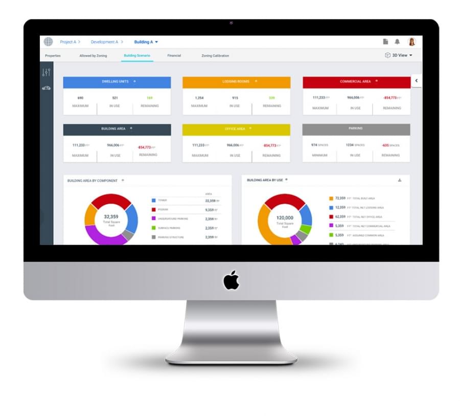
As a leading advocate for open data and civic tech, Mike Sarasti, the City of Miami’s Chief Innovation Officer, explains, “Our city leadership is committed to leveraging technology and finding local partners to solve some of our biggest challenges.  Zoning and planning decisions have an enormous effect on the quality of life in the City of Miami, particularly at this time where we’re experiencing so much growth.  Gridics, homegrown right in our community, understands this, making them an ideal collaborator as work to innovate City processes.


Gridics is quickly expanding to other municipalities around the US.  To learn more about the platform, head over to www.zonar.city.

About Gridics:

Headquartered in Miami, FL, Gridics is a technology company developing software as a service (SaaS) products for the real estate marketplace including their digital zoning platform and hyper-local platform for agents and brokers, Gridics.com.

For more information, visit www.zonar.city or www.gridics.com.

Gridics Releases Q1’17 Miami Neighborhood Trends Report

Every day, there’s a new article predicting the rise and fall of Miami’s notoriously complex real estate market.

To make sense of the speculation, we went back to the data.

Not just any old back of the napkin calculations…  The cold, hard, street-level data.  In other words, we wanted to know exactly what’s happening in our own Miami backyard.

Through the Gridics hyper-local real estate platform, we compiled data across key Miami neighborhoods and cross-referenced those trends with news articles, demographic information, and top agent insight.

Our findings can be found in our first-ever Q1’17 Miami Neighborhood Trends Report.

This report is crucial to the future of your business, and here’s why…

1) Know the Neighborhoods — Every Miami neighborhood is defined by its own set of characteristics.  The prices fluctuate differently, the demographics are varied, and most importantly, the way of life and local hotspots are completely unique.

As a real estate professional, you’re expected to be in fifty places at one time.  We know this is an impossible expectation, so that’s why we compiled neighborhood summaries for you in one report.  Consider it a one-stop-shop for the quarterly real estate pulse in major Miami markets.

2) Stay Two Steps Ahead — The best real estate professionals are the ones who understand where the market has been, what the landscape currently looks like, and how conditions will shift in the future.

The power of Gridics.com, combined with our Q1’17 Market report, provides real estate professionals like you with the insights necessary to stay ahead of your clients and competition.

3) Demonstrate Your Expertise — An organized, intelligent report is one thing.  But we’re taking it one step further…

Now, you can brand/customize your own Q1’17 Market Trends report to send to clients.  Imagine generating an industry-leading real estate report with your picture, logo, and contact information and delivering it to clients with just a few clicks.

There’s no better way to demonstrate your credibility.  Provide value in the form of helpful real estate insights.  Be the expert your clients will rely on again and again.


Gridics Closes $1.1 Million Seed Round

MIAMI, April 20, 2017 /PRNewswire/ — Gridics, a Miami-based real estate technology startup, has announced the successful conclusion of a $1.1 million round of seed funding.  The round was led by Dune Road Capital and included noted accredited investors such as John Dyett, Managing Director of Salem Partners, serial entrepreneur Robert Kall, CEO and co-founder of Cien.ai and leading Miami real estate developer Avra Jain.  The company, which has raised over $2 million of development capital to date, is focused on further strengthening its product and driving adoption of its 3D zoning and planning application.

Gridics, short for Grid Analytics, was founded in 2015 with a vision of combining disparate real estate data sets into a single, hyper-local data platform.  From this platform, the company creates software applications that help users make smarter investment and development decisions while streamlining fractured processes in the real estate world.  The patent-pending 3D zoning application, for example, aims to revolutionize the way cities approach zoning and planning analysis while helping to bridge the gap between the private sector development community of architects, developers and attorneys by automating development feasibility analysis and streamlining the lengthy development plan approval process.

“We are thrilled by the reception we’ve received from cities that have been introduced to Gridics,” says CEO Jason Doyle.  “Our new automated compliance module allows cities and developers to quickly check development plans against site-specific zoning requirements.  Cities that integrate their code with Gridics will streamline their zoning approval processes resulting in faster approvals, improved transparency and significant reductions to backlogs.”

In cities across America, the plan approval process commonly takes nine months or more.  The zoning analysis portion is time-consuming and is a frequent bottleneck in the frustrating process.  At the same time, cities are spending millions of dollars on major planning, transportation and redevelopment projects and must determine optimal zoning changes to drive the development growth they hope to achieve.  Gridics attacks these pressure points by digitizing the rules and regulations of a city’s zoning code and combining it with GIS data layers.  This allows users to quickly and easily produce use-specific and geo-specific 3D visualizations of building massings, saving tens of thousands of dollars and months of analysis while improving the accuracy of their results and forecast models.

“Gridics solves a huge problem,” says Peter Richards, managing partner of Dune Road Capital.  “By creating a solution that can digitize and automate any zoning code, the Gridics team has created a way to streamline an antiqued process.  The Gridics application unshackles real estate professionals, and the municipal departments they interact with, from the zoning books they tirelessly flip through.  Because it increases productivity and saves time and money, Gridics has the ability to become the digital and interactive zoning platform that cities and developers have been waiting for.”

Gridics recently announced the beta launch of their Market Intelligence application, which allows real estate professionals to conduct hyper-local market analysis across the Gridics database.  Over 1,000 members of the MIAMI Association of Realtors have joined Gridics since February.  Gridics plans to expand their Market Intelligence application to other Realtor associations in the future.

About Gridics:

Gridics is a real estate data and software development company.  The Gridics hyper-local dataset powers two products, 3D Zoning and Market Intelligence.  Learn more by visiting www.Gridics.com and www.Zonar.City.

Media Contact:

Austin Rhoads

Puente.co

(919) 414-9206

155659@email4pr.com

Company Contact:

Felipe Azenha

Gridics

(305) 498-9410

155659@email4pr.com

SOURCE Gridics, LLC

Related Links

http://www.gridics.com