Request Demo

Florida Cities Turn to Gridics to Digitize Parcel-Level Zoning & Housing Data

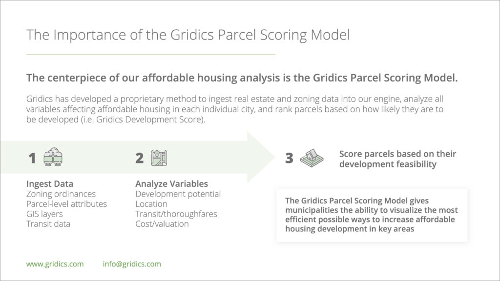
Gridics’ Municipal Zoning Platform Enables Citizen Self-Service, Smarter Planning

For Immediate Release: March 10, 2021

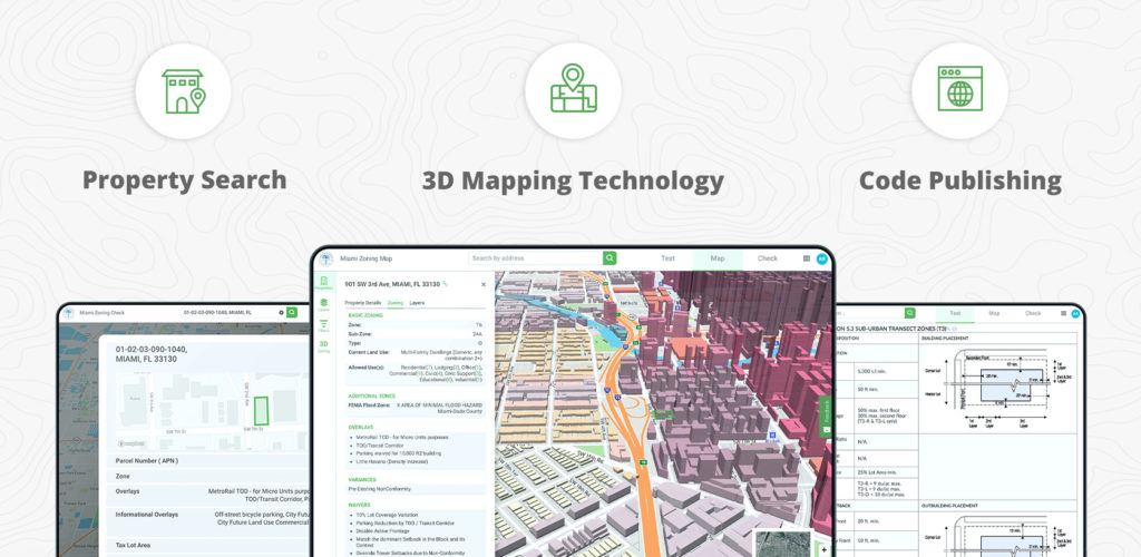
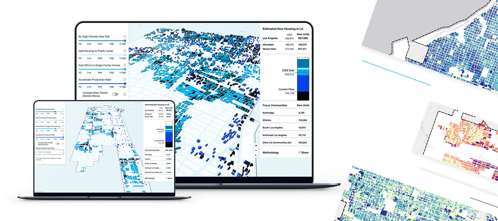
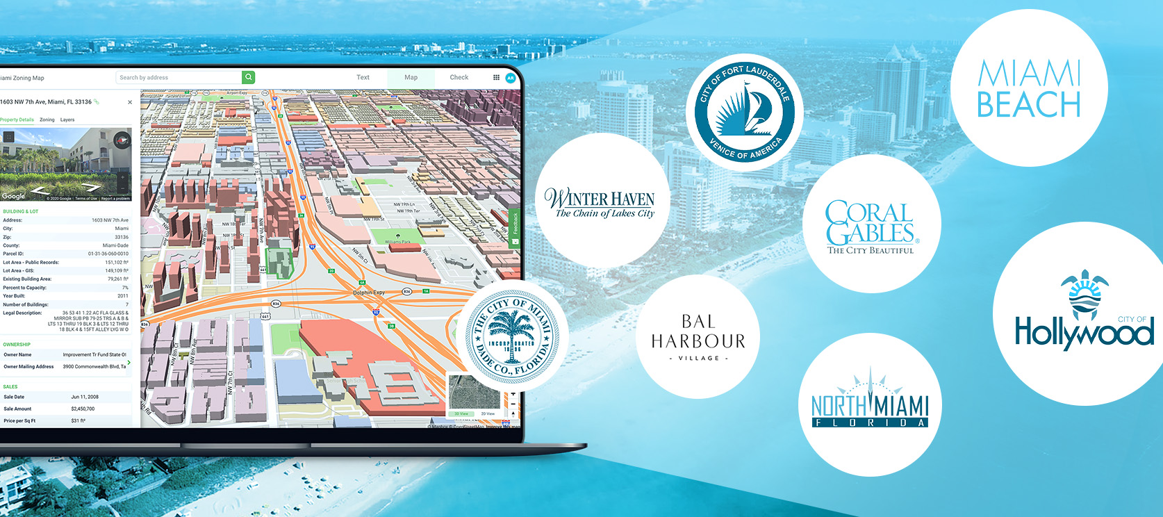
Miami, FL – Gridics LLC, a Miami, FL, based technology company, is revolutionizing zoning, housing and development capacity analysis with its patented zoning calculation engine, providing cities with detailed zoning data for every parcel. Using the Gridics platform, staff and citizens gain remote access to the data via a unified zoning portal which combines property search tools, code text publishing and a robust 3D zoning map. Since the launch of its Municipal Zoning Platform less than two years ago, Gridics has been adopted by numerous Florida cities of all sizes and with varying levels of complexity in zoning, including Miami and Fort Lauderdale.

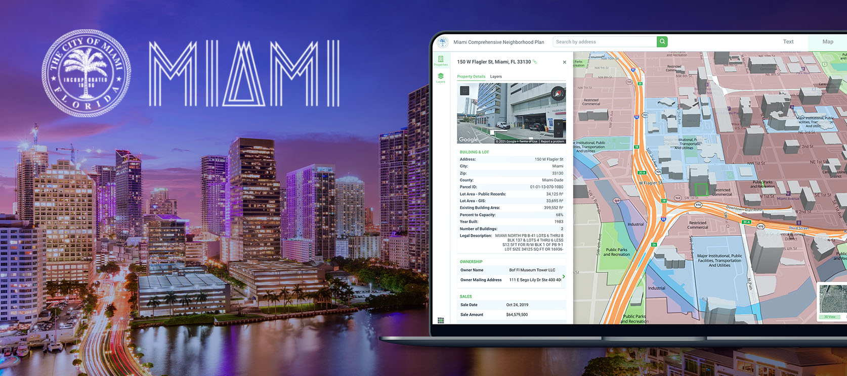
The City of Miami recently expanded its Gridics partnership with the addition of its new Comprehensive Neighborhood Plan hosted on the Gridics platform. “Our partnership with Gridics has been outstanding, and through the [Gridics Municipal Zoning] platform, we’re providing innovative new tools to the public, while increasing process efficiency and reducing costs,” said Mike Sarasti, the City of Miami’s Chief Information Officer and Director of DoIT.

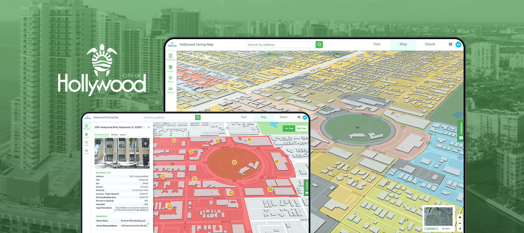
Their most recent addition, the City of Hollywood, FL, is the second largest city in Broward County. The Gridics platform aims to make it easier for residents, investors and developers to do business and interact with the city to get the information they need as efficiently as possible. “These new tools developed by Gridics allow Hollywood users to easily and quickly see the City landscape and the options available to them for building and development,” says Raelin Storey, City of Hollywood Director of Communications, Marketing and Economic Development.

The City of Miami Beach, FL, recently announced the start of a zoning code rewrite and turned to the Gridics platform to visualize their existing code in 3D via the Gridics MuniMap to be able to make it easier to visually convey to citizens and stakeholders the proposed code changes while improving citizen information access in the meantime. “Gridics developed cutting edge technology that facilitates analysis of a city’s zoning ordinance and allows for the visualization of changes in a built environment,” says Carmen Sanchez, Deputy Planning Director, Miami Beach.

In addition to the larger Florida cities above, Gridics has also been adopted by Coral Gables, North Miami, Winter Haven and Bal Harbour Village. “It was important to us to ensure we could service cities large and small. We’ve designed and built a next generation online zoning information platform that is affordable and easy to implement,” says Doyle.

“Our mission is to help build better cities and we’re doing that by arming cities with in-depth zoning and development capacity data for every parcel in their city for the first time ever,” says Jason Doyle, CEO of Gridics. “The old way to determine how zoning applies to a specific property requires citizens and developers to read through the zoning text and try to figure out how the various rules apply to their property. Most give up and contact city staff. We bridged that gap with our technology, making it easier for developers and citizens to get the zoning data they need via self-service apps, freeing up resource constrained staff. Without a zoning property record database for every parcel in your city, it’s like needing to ask for directions to go anywhere versus using the GPS map on your smartphone,” says Doyle.

About Gridics: Gridics provides real estate data and software applications for cities and counties in the area of zoning and economic development. For more information, visit www.gridics.com.

Gridics property search, 3D mapping, and code publishing

Using Our Calculated Data to Address the Affordable Housing Crisis

A look at how Gridics’ proprietary zoning technology helps municipalities calculate and visualize the impact of policy changes on housing capacity in real-time 3D

To view our full affordable housing report, please click here.


Background: The Affordable Housing Crisis

Municipalities across the US are grappling with a systemic problem that is worsening by the day: a lack of affordable housing

Rents have dramatically outpaced wages for the last decade, which has led to cost-burdened households in cities across the country. The affordable housing crisis is not new, though it is being exacerbated by the global pandemic, economic instability, inequality, policy decisions, rising construction costs, and a lack of transportation infrastructure.

For most municipal governments, addressing affordable housing begins with an understanding of the problem… Unfortunately, city officials don’t know where to begin.

Officials are going around in circles trying to answer questions such as:

• Are my city’s zoning ordinances too restrictive?
• Are my city’s regulations and processes not development-friendly?
• How is transportation making the crisis worse?
• What role do labor and material costs play in encouraging/limiting development?


How Gridics Addresses the Affordable Housing Crisis

Gridics has helped municipalities large & small analyze housing data, model the implications of each variable in 3D, and provide data-driven insights for policy recommendations.

Our technology and services encompass 5 areas:

1) Deep Urban Planning Experience
Examining ordinances with our team of experts who have written codes around the world

2) GIS Analysis
Applying rich GIS capabilities at the parcel, block, and entire city level

3) Parcel Scoring Model and 3D Visualization
Leveraging our patented technology to visualize citywide development capacity

4) Scenario Planning and Forecasting
Understanding the timeline and effect each variable has on affordable housing supply

5) Data-Driven Decision Making
Providing insights for policy recommendations based on 3D scenario analysis and capacity calculations


Getting Started With Gridics for Your Municipality

For more information about Gridics or to speak with our team, please contact info@gridics.com.

To view our full affordable housing report, please click here.

affordable housing problems, gridics solutions
5 ways gridics addresses the affordable housing crisis
the gridics parcel scoring model

The City of Miami Gives Easy Online Access to Miami Comprehensive Neighborhood Plan With Gridics

This week, the City of Miami added the Miami Comprehensive Neighborhood Plan (MCNP) onto the publicly-available Gridics Municipal Zoning Platform, CodeHUB. The MCNP is a key zoning document that creates the policy framework that guides all future public and private development decisions in the City of Miami to ensure the City meets the needs of existing and future residents, visitors and businesses, while preserving the character and quality of its communities.

The incorporation of the MCNP into CodeHUB will help to drive smarter regional planning decisions for the future by integrating future land use, environmental, and infrastructure requirements into an interactive, parcel level, 3D map. This is the first time that the MCNP has been made available to the public in such an interactive and accessible tool, allowing the public to be actively involved in understanding the direction of their community, including how the infrastructure will change to support future growth. The most updated version of the MCNP and Future Land Use Map (FLUM) will be made available 24/7 through this new platform.

This week’s online publication of the MCNP follows the successful 2018 launch of the Miami 21 Zoning Code on the Gridics platform, providing citizens an up-to-date and fully digitized version of Miami 21, plus parcel-specific lookup tools for citizens to get zoning property record data for their property or parcel.

About Gridics: Gridics develops real estate data and software applications in the area of zoning analysis and interpretation, scenario planning, site-selection and urban planning professional services. For more information, visit www.gridics.com.

City of Hollywood Adds Gridics 3D Interactive Zoning Map and Additional Tools to Optimize User Experience

The City of Hollywood has launched the Gridics 3D zoning map, text and property data platform. This new online tool brings simplicity, transparency and efficiency for City planners, residents, developers and those trying to research the City’s zoning code and development regulations. The new tool helps in three ways.

  • First, a 3D interactive map with zoning code allows users to visualize the buildable capacity of every parcel in the City as allowed by zoning. The interactive map combines a wide range of data layers for a more complete understanding of the parcel. The tool also enables publishing code text changes in real-time.
  • Second, the online property lookup tool delivers deep, parcel-specific zoning data to help users get the answers they need.
  • Third, the City’s Code of Ordinances and Zoning and Land Development Code have been digitized into an easily searchable tool.

The Gridics platform aims to make it easier for residents, investors and developers to do business and interact with the City and get the information they need as efficiently as possible. “These new tools developed by Gridics allow Hollywood users to easily and quickly see the City landscape and the options available to them for building and development,” says Raelin Storey, City of Hollywood Director of Communications, Marketing and Economic Development.

“The technology is very powerful and provides a quick view and searchable, integrated options for a fast and easy user experience,” says Shiv Newaldass, Director of Development Services for the City of Hollywood. “We’re are extremely excited to be able to offer these tools to our customers.”

The City’s Code of Ordinances and Zoning and Land Development Code have also been converted into an easily searchable tool for customers’ ease of use.

Start using the interactive suite of tools today.

About Gridics: Gridics develops real estate data and software applications in the area of zoning analysis and interpretation, scenario planning, site-selection and urban planning professional services. For more information, visit www.gridics.com.