Request Demo

Gridics Recognized as GovTech 100 Company for Second Consecutive Year

Launch of CodeHUB Zoning Platform Propels Gridics to Forefront of Government Technology

MIAMI, Jan. 15, 2020 — Gridics LLC, a real estate tech and data company, today announced its recognition as a GovTech 100 Company for the second consecutive year.  The annual GovTech 100 list is the result of a competitive, in-depth review of companies focused on, making a difference in, and selling to state and local government agencies across the US.

“Year five of the GovTech 100 is one of the strongest we’ve seen, as companies both large and small are tackling more complex problems around state and local government,” said e.Republic Chief Innovation Officer Dustin Haisler.

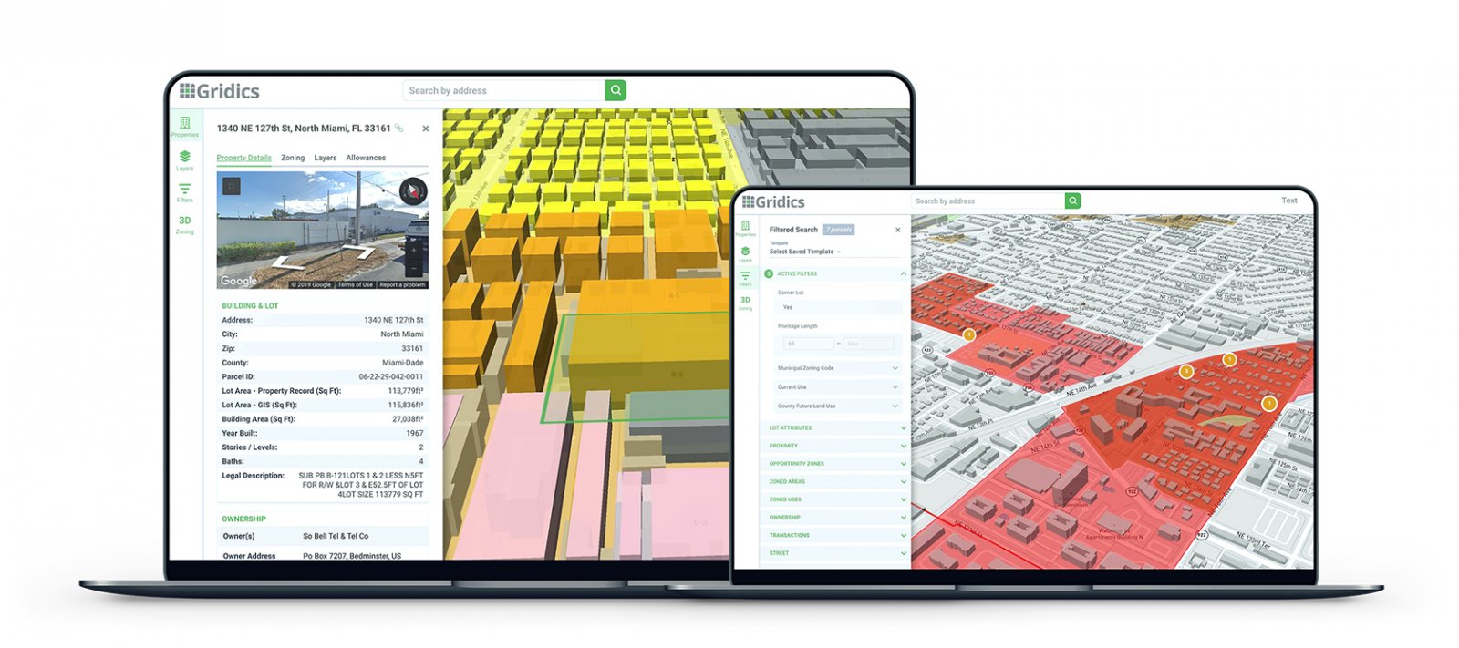
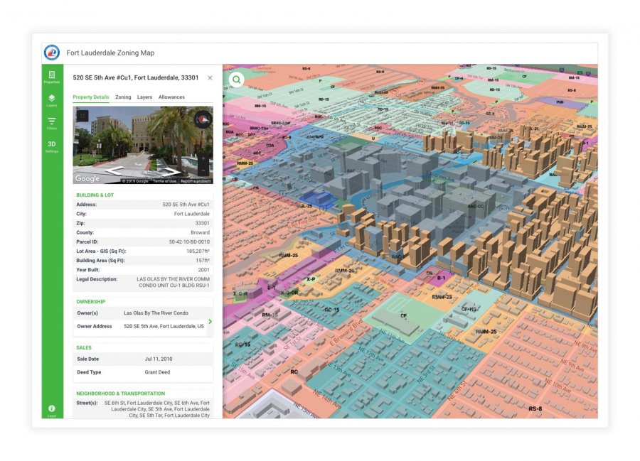
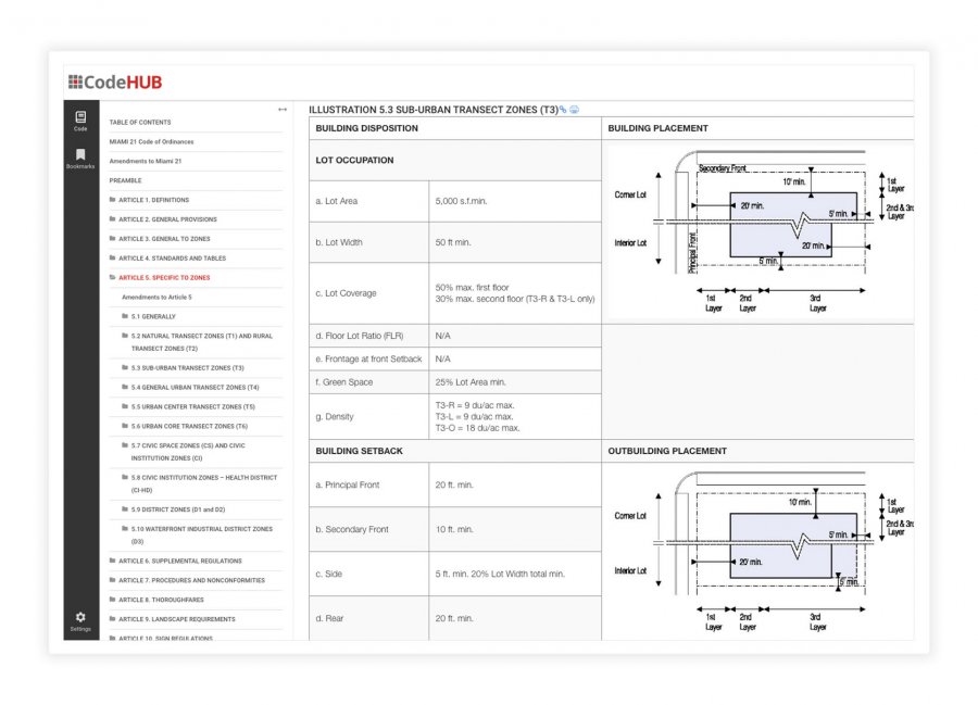
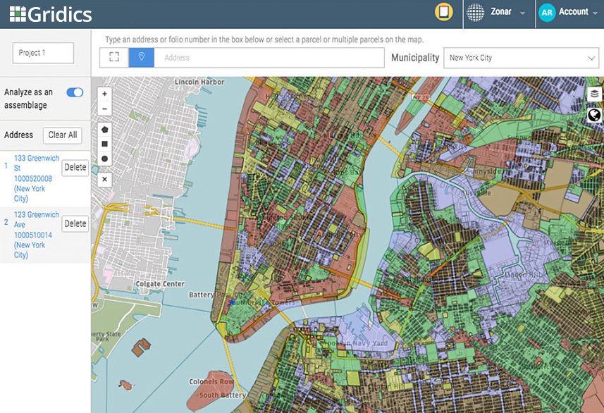
Gridics’ nomination comes on the heels of a successful year defined by a string of new city adoptions, platform market expansion to new major metros, and the release of the world’s most advanced municipal zoning platform, CodeHUB by Gridics.  Since its launch in February 2019, CodeHUB has become the only data driven zoning publishing platform available to cities, combining the published text with a 3D mapping and citizen self service tools.

“We’re honored to be named a GovTech 100 company for the second year in a row.  This recognition underscores our commitment to making local government more efficient,” explains Gridics CEO, Jason Doyle.  “Municipal zoning has long been too confusing for citizens to interpret.  Our patented technology digitizes a city’s zoning ordinance into parcel-specific data and visualizations.  With that data, we are able to deliver unique citizen service tools and staff software applications which reduce low-value staff time spent answering basic zoning questions and improves overall transparency.  As we look to 2020, we are excited to be leading the way in the world of tech-enabled planning and zoning and look forward to partnering with more cities.”

About Gridics:  Gridics develops real estate software applications, data and professional services with a focus on zoning interpretation and development analysis.  For more information, visit www.gridics.com.

Gridics Adds City of Miami Beach, Bal Harbour Village to Platform

Florida cities on front lines of sea level rise adopt Gridics platform to help visualize zoning changes.

For Immediate Release:  September 25, 2019

Miami, FL – Gridics LLC, a real estate tech and data company, today announced the City of Miami Beach and Bal Harbour Village are the latest Florida cities to adopt the Gridics 3D zoning map, text and property data platform to bring simplicity, transparency, and efficiency to what can otherwise be a very complicated process for city planners and residents trying to understand zoning code changes and potential.

Gridics helps municipalities in three ways.  First, a unified 3D interactive map and zoning code website allows municipal staff and citizens to visualize the buildable capacity of every parcel as allowed by zoning and publish code text changes in real-time.  Second, online property lookup tools deliver deep, parcel-specific zoning data to help citizens get answers to common zoning questions which significantly reduces phone calls and in-person visits to the planning staff.  Third, municipal staff members can easily run 3D scenario analysis of current zoning allowances, visualize proposed zoning changes and more quickly check permit applications and development plans for compliance.

For low-lying coastal communities like Miami Beach and Bal Harbour grappling with sea level rise and the broader impact of climate change on their built environment, zoning changes are a key piece of the solution puzzle.

“Gridics has developed cutting edge technology that facilitates analysis of a city’s zoning ordinance and allows for the visualization of changes in a built environment.  The technology provides transparency to the public as the community and elected officials consider the benefits and impacts of proposed projects.  Additionally, having zoning text and zoning map integrated allows the city to update its zoning ordinance quickly and efficiently.”  Said Carmen Sanchez, Deputy Planning Director Miami Beach.

The Gridics platform aims to make it easier for citizens, investors and developers to do business and interact with municipalities by bridging the communication gap that the existing municipal zoning text publishing and mapping tools perpetuate.  This ranges from large initiatives such as helping citizens and elected officials to visualize proposed zoning changes to more everyday processes like reducing the time staff spends servicing basic zoning questions both in person and via phone.

“We’re thrilled to add Miami Beach and Bal Harbour to the Gridics municipal network” said Jason Doyle CEO of Gridics.  “Our team of urban planners and software engineers are passionate about helping to build better cities and that starts with progressive and innovative municipal partners focused on leveraging the latest technology and tools to make them easier to work with.”

Other Florida jurisdictions that have adopted Gridics include Miami, Fort Lauderdale and North Miami to name a few.

About Gridics:  Gridics develops real estate data and software applications in the area of real estate development analysis and interpretation.  For more information, visit www.gridics.com.

Gridics Expands Market Coverage to Los Angeles, Dallas, Austin, Denver and More

3D development feasibility software and API available in more major cities; opportunity search to follow

For Immediate Release:  June 25, 2019

Miami, FL – Gridics LLC, a Miami-based real estate tech and data company, today announced the expansion of its real estate development analysis platform to include six more major cities.  The Gridics platform allows users to calculate and visualize, in 3D, the development feasibility and capacity of a parcel or assemblage of parcels, inclusive of complex considerations like zoning overlays, use specific allowances and parking requirements.

The Gridics platform is used by real estate developers, investors, brokers and municipalities.  Launched two years ago, Gridics started with Miami before adding New York City and a number of other cities that contract to use the platform in their zoning and planning departments.  With this announcement, Gridics platform users can now analyze parcel-specific zoned development opportunity in Los Angeles, Denver, Dallas, Austin, Orlando and Kansas City.

“Parcel-specific zoning data and attributes are used in numerous areas of the multi-trillion-dollar real estate vertical and is a major driver of development decision making as well as valuation,” says Jason Doyle, CEO of Gridics.  “Yet given the broad written structure of municipal zoning regulations, determining how zoning regulations apply to specific parcel shapes has always been a manual process, resulting in laborious research costs and permit approval delays.  Our technology delivers this important data in real-time.”

In the coming months, Gridics plans to add Chicago, Detroit, Tampa, Jacksonville, San Antonio, El Paso and Washington DC.  In addition to individual application use, enterprise users can utilize the Gridics API to pull real-time property zoning data such as applicable zones and overlays, maximum buildable area, maximum footprint, allowable addition, height, density, setbacks and more.

“After years of development, our engine and data has been pressure tested by many different city zoning departments,” says Doyle.  “We are now aggressively scaling our coverage into all the major markets and in doing so are amassing an ocean of proprietary real estate data that we will leverage to drive smarter development and investment decisions while creating greater efficiencies across the real estate spectrum.”

As Gridics expands the coverage of its calculated development data footprint, it is working with leading commercial brokerage firms and developers to deliver a first-of-its-kind development opportunity and site-selection search.  Users of this new app will be able to search for properties based on the Gridics development potential data and gain unique insights into untapped property values.  It is expecting an alpha launch later this summer.  To gain early access, send an email to info@gridics.com.

About Gridics:  Gridics develops data and software applications in the area of real estate development analysis and interpretation.  For more information, visit www.gridics.com.

Gridics Expands Municipal Zoning Platform with the Launch of CodeHUB

Miami, FLGridics LLC, recently recognized as a GovTech100 company, today announced the expansion of its municipal zoning and planning platform with the addition of the first ever unified code text publishing and 3D zoning map product called CodeHUB.

Cities adopting CodeHUB will, for the first time ever, be able to self-publish their zoning code changes in real-time and deliver to citizens an easy to use zoning map with property lookup, and 3D visualization capabilities.  The combination of the two within a single public website application allows for the delivery of a more contextual end user experience at the property specific level while improving public transparency.  With the addition of the CodeHUB product, Gridics now delivers the only true comprehensive zoning management platform for cities.

Gridics launched its municipal zoning platform in 2017 with the unveiling of the first ever 3D planning and zoning software, ZoneIQ.  Targeted to city planners, ZoneIQ allows city staff to generate 3D massing visualizations, as regulated by zoning, of selected parcels with a few clicks.  They quickly saw adoption by cities large and small including Miami, FL and Cupertino, CA and more recently secured a pilot with the planning department of the nation’s largest city, New York.

“As we began to help city planning staff visualize and interpret their ordinance for tasks like testing zoning changes and checking plans for compliance, we observed staff spending a lot of time fielding zoning questions from citizens,” explained Jason Doyle, CEO of Gridics.  “We determined that nearly every city is spending valuable staff resources reacting to questions from citizens either because their current method of publishing their code text is outdated or because the zoning map doesn’t tell them how the written rules apply to their specific parcel.  This makes it harder for citizens and businesses to work with cities and creates a costly domino effect on city resources.  It quickly became clear we were uniquely positioned to solve this problem by extending our site-specific zoning calculation capabilities to citizens by creating the first ever 3D zoning map and code text publication website that cities can update in real-time.  By adding CodeHUB to ZoneIQ, cities now have a truly unified digitized zoning platform that improves staff productivity, helps commissioners make more informed decisions and significantly improves citizen transparency.”

After announcing CodeHUB in late 2018 to select cities, Gridics secured adoption by four Florida cities and is now opening up the service nationwide.  According to a recent survey of 602 cities by leading Planning website Planetizen, of the 85% of cities are publishing their text online, 33% publish a PDF document of the code while 42% use a third party online publishing service and just 58% provide an online property lookup map.

“None of the current solutions in use by cities bridge the gap between text, map and city staff on a single platform,” says Doyle.  “We are aiming to push innovation into zoning on all levels and it starts with simplifying processes by unifying disparate information sources.”

To learn about the Gridics Municipal Planning and Zoning Platform, please visit www.gridics.com

About Gridics:  Headquartered in Miami, FL, Gridics develops targeted software applications for municipalities and real estate professionals in the areas of data, planning, zoning and permitting.

Gridics Fort Lauderdale 3D zoning map
Gridics CodeHUB zoning code text platform
Gridics Fort Lauderdale zoning map search

Gridics Recognized as a GovTech 100 Company Making a Difference in Municipal Planning & Zoning

Government Technology Magazine, a leading publication covering information technology’s role in state and local government, recently named Gridics as a GovTech 100 company for 2019.

Each year, GovTech.com analyzes the top software companies based on investment capital, sales, industry niche, and impact across all levels of government.

“Four years in, the GovTech 100 continues to provide a glimpse at the most innovative companies partnering with government to solve mission-critical problems,” said e.Republic Chief Innovation Officer Dustin Haisler, who was heavily involved in the list’s creation.

Gridics is featured in this year’s report alongside transformative companies such as OpenGov, Tyler Technologies, and the Boring Company, Elon Musk’s project to help cities combat crippling traffic gridlock.  As the only intelligent zoning company on the list, Gridics stands in a category of its own.

“It is an honor to be highlighted among the 2019 GovTech 100 companies,” says Jason Doyle, CEO of Gridics.  “From day #1, our team has been on a mission to change the way municipal governments solve zoning and planning challenges.  The GovTech 100 recognition is validation that Gridics is creating technology to help build better cities and underscores just how important visualizing development capacity, driving economic development, and increasing zoning transparency are to the future of cities.”

Numerous municipal governments including New York, Miami, Fort Lauderdale, and Cupertino are already using Gridics, the world’s first 3D zoning management engine.  From managing zoning code text online to understanding future development in 3D, Gridics brings never-before-seen transparency to city zoning.

Curious to learn how the Gridics technology platform can help you build a better city?  For more information, please visit www.gridics.com or contact us at info@gridics.com.

Gridics Expands 3D Zoning & Development Analysis Software to New York City

Register for a free trial:  https://www.zonar.city/trial-request

RSVP for NYC Launch Webinar:  https://attendee.gotowebinar.com/register/2657057101475429121

MIAMI, June 20, 2018 — Gridics LLC, a Miami-based software company, today announced the expansion of its 3D Development Analysis Platform to New York City.  This platform allows users to select a parcel or assemblage of parcels on a map and in seconds visualize in 3D the development allowance according to the regulations in the written code; a process that traditionally takes weeks and costs thousands of dollars.

After starting with the City of Miami last year, Gridics has begun expanding their 3D zoning code management platform to more cities including Fort Lauderdale and now New York City.  Gridics is a browser-based application that helps developers and commercial brokers quickly understand parcel-specific development potential inclusive of uses and parking requirements while also allowing for creation of customize usage scenarios such as residential, office, lodging or mixed use.  Subscribers can assemble multiple adjoining parcels, generate branded PDF property zoning reports and even share the project publicly with non-subscribers to view on a browser based 3D map.

“We are thrilled with our expansion of our 3D zoning code management platform to the largest real estate development market in the world,” said Jason Doyle, CEO of Gridics.  “The inability to easily interpret, visualize and understand site-specific development potential due to complex written zoning regulations adds significant costs and inefficiencies to the real estate acquisition, development, analysis and funding process.  Our patent-pending geospatial rules engine unlocks those complexities at a site-specific level to deliver a common means for cities and their real estate community to easily visualize and understand how zoning impacts each property.”

Gridics comprehensive zoning code management platform also includes applications for cities to deliver real-time code text updates to the public as well as an interactive 3D zoning map product.  In addition, many cities are using the platform in their planning and zoning departments to quickly analyze the impact of proposed projects, test zoning code changes and expedite development plan reviews.

“Gridics has literally cracked the code with their 3D technology,” says Daniel Lebensohn, Managing Partner of BH3, a Manhattan and Miami based developer.  “If you’re a developer or broker in NYC and don’t have the ability to quickly analyze opportunities using the Gridics engine, you are falling behind.”

As a special launch offer and to encourage usage and feedback, Gridics is allowing trial users in NYC to upgrade to their top tier package, Expert, at the price of their entry level package for a limited time.  To learn about the platform, please visit www.zonar.city.

About Gridics:  Headquartered in Miami, FL, Gridics develops unique data and software applications in the area of real estate zoning analysis and interpretation.  For more information, visit www.gridics.com.

The One Thing Your Smart City (Probably) Doesn’t Have

There’s been a lot of talk lately about “Smart Cities”.  So what is a Smart City?  According to Techopedia:

“A smart city is a designation given to a city that incorporates information and communication technologies (ICT) to enhance the quality and performance of urban services such as energy, transportation, and utilities in order to reduce resource consumption, wastage and overall costs.  The overarching aim of a smart city is to enhance the quality of living for its citizens through smart technology.”

The Smart City movement seems to be predicated on the embedding of computerized sensors into the urban fabric.  This means that car and bike shares, parking, lamp posts, traffic lights, home appliances such as internet fridges and remote-controlled HVAC systems, all become part of the so-called “internet of things”.

One of the latest companies to launch a Smart City project is Sidewalk Labs, a Google company, which will attempt to build a “Smart Neighborhood” in Toronto.  Last year Sidewalk Labs partnered with Waterfront Toronto to bring planning, process, community, and technology together in order to develop more than 800 acres of vacant land that sits just southeast of Downtown Toronto.

We should applaud Sidewalks Labs, a holistic approach to urban planning, development, and construction.  This type of out-of-the-box thinking is what drives innovation.  However, technology alone won’t considerably improve the quality of life in our cities.

Technology and data collection are powerful and can help us better plan our cities as well as increase efficiencies.  However, if we truly want to build cities that have an excellent quality of life we need to get zoning right.  If your city’s zoning code promotes sprawl and automobile dependency Smart City technologies won’t save your city.

The invisible hand that guides a city’s development and future growth is zoning.  Zoning builds the foundation of your city.  If your city’s zoning code doesn’t encourage density, mixed-uses, walkability, transit/mobility options and reduced parking requirements there is probably little or no hope for your city.  If the end goal is to build a city that is walkable, transit-friendly and less reliant on the automobile, start with smarter zoning or you’ll end up like Tucson, Arizona or Houston, TX.

When thinking of “Great Cities” Toronto, London, Vancouver, Seattle, Paris, Tokyo, Vienna, and Curitiba all come to mind.  What makes the quality of life so great in these cities?

Great cities:

  • Are walkable
  • Encourage density
  • Provide mobility options (transit, biking, walking)
  • Are less reliant on motor-vehicles
  • Have reduced or eliminated minimum parking requirements

So if you want a want a Smart City, start with smarter zoning.

City of Delray Beach, FL Adopts World’s First 3D Zoning Code Application

Gridics partnership will result in a 3D zoning map of Delray Beach and development analysis capabilities

For Immediate Release:  January 11, 2018

Miami, FLGridics LLC, a Miami-based real estate tech startup, today announced a partnership with the City of Delray Beach, FL to use its 3D zoning code management application. The Gridics application is the first interactive digital zoning code program of its kind and is designed to change the way cities manage and interact with their cumbersome zoning needs.

By adopting this technology, the City of Delray Beach will be able to integrate its zoning code into the Gridics proprietary rules-engine so that all the regulations, variables, property records and parcels can be manipulated and analyzed in real-time on a 3D map interface.  Gridics is a cloud-based application capable of integrating any city’s zoning code to deliver immediate as-of-right building scenarios.  Additionally, once a city’s code is digitized, users can expedite development plan compliance reviews and visually test proposed zoning code changes.

As part of the partnership with Delray Beach, Gridics will work with the city’s planning department to create an online, interactive 3D zoning map.  Cities that integrate their code with the Gridics platform are newly enabled to easily answer community questions regarding building parameters and can more quickly analyze development plans for compliance to reduce plan review backlogs.

“Gridics’ 3D technology forms an integral part of our efforts to continue enhancing our Central Business District.  We can now test zoning code changes in real time and see how new development will affect the overall character and scale.” said Tim Stillings, Director of Planning, Zoning, & Building for the City of Delray Beach.  “Gridics makes it easy to manipulate planning and zoning scenarios and see the results graphically saving time and improving communication.”

Founded by three University of Miami graduate students with backgrounds ranging from urban planning and architecture to real estate tech and engineering, Gridics is focused on developing innovative solutions to complex, data-driven problems in the world of real estate.  The team partnered with the City of Miami and some of Miami’s leading real estate developers and architects to uniquely position the software and tune its accuracy before launching the product in late 2017.  The City of Miami has since signed a contract with Gridics to use its platform to enhance their zoning and planning operations.

“We’ve solved a complex problem with Gridics that is helping cities large and small convert their written development regulations into a web-based, property-specific 3D visualization tool.” says Jason Doyle, CEO of Gridics. “We’re excited to partner with a progressive city like Delray Beach that has been setting a strong example for other cities to follow with its planning practices.”

To learn about our 3D technology for your city, county, or private sector real estate firm, please visit www.zonar.city or register for one of our free and open webinars held every two weeks (https://webinars.zonar.city).

About Gridics:  Headquartered in Miami, FL, Gridics is a real estate technology company developing targeted software applications in the areas of real estate development, zoning and market analysis.  For more information, visit www.zonar.city or www.gridics.com.

About the City of Delray Beach:  Delray Beach is a first-class resort destination and a diverse, vibrant, community situated on the Atlantic Ocean between Boca Raton and West Palm Beach.  Home to 67K residents, Delray Beach is only an hour north of Miami and a three-time winner of the coveted All-America City Award (1993, 2001, 2017).

Baker Barrios Architects to Adopt Gridics 3D Technology for Orlando Projects

ORLANDO, Fla. (Dec. 4, 2017) — Gridics LLC, a real estate technology company headquartered in Miami, is pleased to announce its most recent partnership with Baker Barrios Architects, one of the most innovative commercial architecture and design firms in the Southeast.

Baker Barrios Architects will be using Gridics’ 3D zoning and planning application to effectively identify parcels, create development scenarios and feasibility studies, and test architecture projects against local zoning codes.

Developed by expert architects and urban planners, Gridics is the world’s first site-specific 3D zoning and planning software.  Governments including the City of Miami have already adopted its technology to expedite their development plan reviews with local private sector firms following suit.  With just a few clicks, private sector real estate professionals such as architects, attorneys, developers, and brokers can visualize the zoning capacity of any parcel in a given city/county in 3D.

“Our partnership with Baker Barrios supports our expansion into the Orlando market and, more importantly, will provide us a valuable customer feedback loop to drive continued product improvement,” said Jason Doyle, CEO of Gridics.  “We are excited to work with the team at Baker Barrios to help strengthen their business and service through the use of our platform.”

Founded in 1993, Baker Barrios Architects has grown considerably and has projects ranging from arts and entertainment centers to office complexes and multifamily residential.  Baker Barrios’ expertise in both architecture and planning is ultimately what drew the firm to the Gridics product.

“We’re always on the lookout for new technologies to improve our work quality and efficiency and Gridics’ 3D capabilities do just that,” said Tim Baker, CEO and principal of Baker Barrios Architects.  “Feasibility analyses that used to take our team hours, if not days, of work can now be completed in a few minutes.”

As Gridics continues its expansion in Orlando and other cities around the globe, partnerships like these will be crucial to spreading adoption among the private sector.

To learn more about Gridics in your city, register for one of the free open webinars held on Wednesdays from 1-1:30pm EST:  https://webinars.zonar.city

About Gridics:  Headquartered in Miami, Gridics is a technology company developing SaaS applications for the real estate marketplace including their digital zoning platform and their hyper-local Market Intelligence platform for agents and brokers.  For more information, visit www.zonar.city or www.gridics.com.

About Baker Barrios:  Baker Barrios Architects, Inc. is among the most innovative commercial architecture and design firms in the Southeast.  Spanning more than two decades, the company has practiced a sustainable approach to architecture through a strikingly wide range of work from world-class entertainment, hospitality and retail environments to corporate, education, healthcare and multi-family residential properties.  Headquartered in Orlando, with projects throughout the United States, the service based practice includes architecture, interior design, planning, landscape architecture, structural engineering, branding and communications.  Since its inception in 1993, Baker Barrios continues to enrich communities by providing the next generation of design.