Request Demo

Gridics is Growing >> New Cities, New Products… New York City! New Orleans?

Hi there Gridics family,

This is our first quarterly newsletter.  If you’re receiving it, we somehow determined you might care about what we’re up to.

We’re going to try to make it insightful each time and not bombard you with garbage.  So here it goes…

Gridics is Growing!

We’re laser-focused on making Gridics the 3D zoning code software platform used by every city everywhere.  After launching this time last year, the City of Miami was the first city to adopt our 3D software platform.

Since January 1st, two more Florida cities have adopted — Fort Lauderdale and Delray Beach.

AND >> most recently (announced here first) we have added our first two cities outside of Florida…in the land of APPLE and the BAYOU!

That’s right…the City of Cupertino, CA (APPLE’s Headquarters) and Lafayette, LA (the fourth largest city in Louisiana)!

We’re off to a great start in 2018 and are looking forward to our continued growth.

New Products Are Here!

CodeHUB is coming….Cities have spoken, and we have listened.

The end is near for updating zoning code PDFs multiple times per year and shipping them off to some outside website.  Over the last few months, we have been busy building the future of code text management with feedback from cities.

New York City — Yes We Did!

We recently implemented the entire New York City zoning code (4,000+ pages) into our 3D application.  Subscribers can now run real-time development feasibility scenarios for lots across all five boroughs.

We nailed it — we have confirmed that for irregular shaped lots, our proprietary geometric measurement and calculation process is producing the most accurate buildable capacity data available.

Join Us for MARDI-GRIDICS in NEW ORLEANS!

Are you attending the American Planning Association’s national conference in New Orleans from April 21st – 24th?  Come meet Felipe, Austin, and Me!  We will have a booth in the exhibit area.

BUT WAIT there’s more…

We are hosting an Invite-Only (sorry, limited space) cocktail party at a bar overlooking Bourbon Street on Monday night from 9-12am.  We are limited to 50 people, so we will be sending out invitations to a select list.

If you would like to ensure you get an invite, please send a request to Austin (austin@gridics.com).

We love you!

Jason Doyle

CEO, Gridics LLC

info@gridics.com

City of Fort Lauderdale, FL Adopts World’s First 3D Zoning Code Software Application

Miami, FLGridics LLC, a Miami-based real estate tech startup, today announced a partnership with the City of Fort Lauderdale, FL to adopt its 3D zoning code management platform.  The Gridics software application is an interactive 3D digital zoning code program that is designed to improve the efficiency and transparency by which cities can manage, change and communicate their zoning code regulations.  Once the software is fully implemented with the city’s code, citizens will have access to more detailed, property specific zoning allowance data and paid subscribers will be able to run customized development feasibility scenarios.

By adopting this technology, the City of Fort Lauderdale’s Department of Sustainable Development will add a smart 3D modeling solution to support its urban design, planning, and development application review process.  Gridics’ patent-pending application combines the measurable requirements of a zoning code with property records, parcel shapes and mapped zones.  This provides users with a 3D interactive digital mapping software to help conduct feasibility studies, scenario plans and site plan reviews by assigning descriptive code characteristics such as allowable heights, setbacks and other dimensional requirements to building forms to visualize development outcome scenarios.  The Gridics application will allow planning staff, policy makers, and the public to visualize the effects zoning regulations and zoning changes have on the existing built environment by imagining build-out scenarios or proposed zoning changes.

“Our partnership with Gridics is an example of the innovative investments we are making to improve services for our neighbors,” said John P. “Jack” Seiler, Mayor of Fort Lauderdale.  “The Gridics platform will provide staff with the data they need to make more informed and more efficient development decisions so together we can make Fort Lauderdale an even better place to live, work, play and raise a family.”

“We’re excited to partner with the City of Fort Lauderdale to help them achieve their 3D mapping objectives around zoning and development analysis.”  says Jason Doyle, CEO of Gridics. “Once in place, not only will our software empower the Sustainable Development team at the City of Fort Lauderdale with a robust tool to enhance their operations but it will also be available for private users to subscribe to use in their development preparations and analysis, resulting in streamlined communication between the two.”

To learn more, please visit www.zonar.city or register for one of our free and open webinars held every two weeks (https://webinars.zonar.city).

About Gridics:  Headquartered in Miami, FL, Gridics is a real estate technology company developing targeted software applications in the areas of real estate development, zoning and market analysis.  For more information, visit www.zonar.city or www.gridics.com

City of Delray Beach, FL Adopts World’s First 3D Zoning Code Application

Gridics partnership will result in a 3D zoning map of Delray Beach and development analysis capabilities

For Immediate Release:  January 11, 2018

Miami, FLGridics LLC, a Miami-based real estate tech startup, today announced a partnership with the City of Delray Beach, FL to use its 3D zoning code management application. The Gridics application is the first interactive digital zoning code program of its kind and is designed to change the way cities manage and interact with their cumbersome zoning needs.

By adopting this technology, the City of Delray Beach will be able to integrate its zoning code into the Gridics proprietary rules-engine so that all the regulations, variables, property records and parcels can be manipulated and analyzed in real-time on a 3D map interface.  Gridics is a cloud-based application capable of integrating any city’s zoning code to deliver immediate as-of-right building scenarios.  Additionally, once a city’s code is digitized, users can expedite development plan compliance reviews and visually test proposed zoning code changes.

As part of the partnership with Delray Beach, Gridics will work with the city’s planning department to create an online, interactive 3D zoning map.  Cities that integrate their code with the Gridics platform are newly enabled to easily answer community questions regarding building parameters and can more quickly analyze development plans for compliance to reduce plan review backlogs.

“Gridics’ 3D technology forms an integral part of our efforts to continue enhancing our Central Business District.  We can now test zoning code changes in real time and see how new development will affect the overall character and scale.” said Tim Stillings, Director of Planning, Zoning, & Building for the City of Delray Beach.  “Gridics makes it easy to manipulate planning and zoning scenarios and see the results graphically saving time and improving communication.”

Founded by three University of Miami graduate students with backgrounds ranging from urban planning and architecture to real estate tech and engineering, Gridics is focused on developing innovative solutions to complex, data-driven problems in the world of real estate.  The team partnered with the City of Miami and some of Miami’s leading real estate developers and architects to uniquely position the software and tune its accuracy before launching the product in late 2017.  The City of Miami has since signed a contract with Gridics to use its platform to enhance their zoning and planning operations.

“We’ve solved a complex problem with Gridics that is helping cities large and small convert their written development regulations into a web-based, property-specific 3D visualization tool.” says Jason Doyle, CEO of Gridics. “We’re excited to partner with a progressive city like Delray Beach that has been setting a strong example for other cities to follow with its planning practices.”

To learn about our 3D technology for your city, county, or private sector real estate firm, please visit www.zonar.city or register for one of our free and open webinars held every two weeks (https://webinars.zonar.city).

About Gridics:  Headquartered in Miami, FL, Gridics is a real estate technology company developing targeted software applications in the areas of real estate development, zoning and market analysis.  For more information, visit www.zonar.city or www.gridics.com.

About the City of Delray Beach:  Delray Beach is a first-class resort destination and a diverse, vibrant, community situated on the Atlantic Ocean between Boca Raton and West Palm Beach.  Home to 67K residents, Delray Beach is only an hour north of Miami and a three-time winner of the coveted All-America City Award (1993, 2001, 2017).

Baker Barrios Architects to Adopt Gridics 3D Technology for Orlando Projects

ORLANDO, Fla. (Dec. 4, 2017) — Gridics LLC, a real estate technology company headquartered in Miami, is pleased to announce its most recent partnership with Baker Barrios Architects, one of the most innovative commercial architecture and design firms in the Southeast.

Baker Barrios Architects will be using Gridics’ 3D zoning and planning application to effectively identify parcels, create development scenarios and feasibility studies, and test architecture projects against local zoning codes.

Developed by expert architects and urban planners, Gridics is the world’s first site-specific 3D zoning and planning software.  Governments including the City of Miami have already adopted its technology to expedite their development plan reviews with local private sector firms following suit.  With just a few clicks, private sector real estate professionals such as architects, attorneys, developers, and brokers can visualize the zoning capacity of any parcel in a given city/county in 3D.

“Our partnership with Baker Barrios supports our expansion into the Orlando market and, more importantly, will provide us a valuable customer feedback loop to drive continued product improvement,” said Jason Doyle, CEO of Gridics.  “We are excited to work with the team at Baker Barrios to help strengthen their business and service through the use of our platform.”

Founded in 1993, Baker Barrios Architects has grown considerably and has projects ranging from arts and entertainment centers to office complexes and multifamily residential.  Baker Barrios’ expertise in both architecture and planning is ultimately what drew the firm to the Gridics product.

“We’re always on the lookout for new technologies to improve our work quality and efficiency and Gridics’ 3D capabilities do just that,” said Tim Baker, CEO and principal of Baker Barrios Architects.  “Feasibility analyses that used to take our team hours, if not days, of work can now be completed in a few minutes.”

As Gridics continues its expansion in Orlando and other cities around the globe, partnerships like these will be crucial to spreading adoption among the private sector.

To learn more about Gridics in your city, register for one of the free open webinars held on Wednesdays from 1-1:30pm EST:  https://webinars.zonar.city

About Gridics:  Headquartered in Miami, Gridics is a technology company developing SaaS applications for the real estate marketplace including their digital zoning platform and their hyper-local Market Intelligence platform for agents and brokers.  For more information, visit www.zonar.city or www.gridics.com.

About Baker Barrios:  Baker Barrios Architects, Inc. is among the most innovative commercial architecture and design firms in the Southeast.  Spanning more than two decades, the company has practiced a sustainable approach to architecture through a strikingly wide range of work from world-class entertainment, hospitality and retail environments to corporate, education, healthcare and multi-family residential properties.  Headquartered in Orlando, with projects throughout the United States, the service based practice includes architecture, interior design, planning, landscape architecture, structural engineering, branding and communications.  Since its inception in 1993, Baker Barrios continues to enrich communities by providing the next generation of design.

Gridics Raises $1.6 Million to Expand 3D Zoning Technology

MIAMI, Nov. 7, 2017 /PRNewswire/ — Gridics, a Miami-based real estate software company, announced it has raised $1.6 million in additional Seed capital.  The round was led by BH3, a real estate developer with projects in South Florida and New York City, and Dune Road Capital.  The company will use this investment to accelerate development and sales of its 3D zoning and planning platform to cities and real estate developers.

Gridics was founded on a vision to revolutionize the way cities and real estate developers interact with zoning codes.  By bringing 2D text to a visualized 3D interface the company is streamlining an antiquated process. Earlier this year the company launched a map-based zoning code application and proprietary rules engine that allows users to quickly view a 3D, by-right development potential of a specific parcel or parcels.  In addition, the application enables the customization of usage scenarios such as residential, mixed use, office, hotel or commercial.  Gridics is seeing strong early adoption of the application by city and county planning, zoning and economic development departments as well as developers, architects, commercial brokers and land use attorneys in the private sector.

In April Gridics announced a contract with the City of Miami to use its platform to expedite and streamline the analysis and processing of development plan reviews.  It was then that lead investor BH3 became familiar with Gridics.  “The Gridics technology has become invaluable to our business,” says BH3 Principal, Daniel Lebensohn.  “We are able to identify new development opportunities, quickly run custom scenario analyses and view applicable variances and waivers.  That analysis used to take us days to complete and cost thousands of dollars but can now be handled in a few minutes with Gridics.”

“Since our Miami launch, we’ve seen a very strong response from municipalities, large and small, across the US and even internationally,” said CEO of Gridics, Jason Doyle.  “Gaining the investment support of a leading real estate developer like BH3 after first becoming a customer is the best validation we could ask for.  In the coming months, we will be opening all five boroughs of New York City on the platform and expect to add several direct city contracts.”

Dune Road Capital, the other participant in this round, is an experienced technology investment firm and led a previous round of funding in Gridics.  “We are extremely pleased with the execution by the Gridics team and are thrilled with the initial market response to its 3D platform,” said Peter Richards of Dune Road Capital.  “We believe Gridics is a game changer that revolutionizes the way the real estate community interacts with its workflow.  We are excited to partner with BH3 and believe users wanting to become investors further validates the company’s vision.”

To learn more, head over to www.Zonar.City or visit www.Gridics.com/blog.

About Gridics:  Headquartered in Miami, FL, Gridics is a technology company developing SaaS applications for the real estate marketplace including their digital zoning platform and their hyper-local Market Intelligence platform for agents and brokers.  For more information, visit www.zonar.city or www.gridics.com.

About BH3:  BH3 is an opportunistic real estate firm with a core focus on acquiring real estate in South Florida and New York City. The firm’s portfolio includes Trump Hollywood, 1805 Ponce, Terra Beachside, 6000 Collins, and Fontainebleau Sorrento.  For more information, please visit www.BH-3.com.

Media Contact:

Felipe Azenha

183913@email4pr.com

305-498-9410

SOURCE Gridics, LLC

Related Links

Home

Gridics Identifies 6 Ideal Sites For Amazon HQ2 Campus in Miami

Using Gridics to Analyze Government-Owned Vacant Land Suitable for Amazon

On September 7, 2017, Amazon published a Request For Proposals (RFP) for cities interested in becoming the home of its next headquarters campus.

Amazon’s RFP spells out specific quantitative real estate requirements and qualitative market requirements such as square footage needed, proximity to transportation, and zoning conditions.  It turns out, this kind of detailed analysis is exactly what the Gridics application is designed to automate.

Instead of taking weeks using traditional methods, Gridics produced the precise report within hours.  Our full comprehensive real estate zoning and development analysis report highlighting the viable development sites for Amazon’s potential second heaquarters can be found here.

www.zonar.city/case-study/Amazon-Headquarters

How We Conducted the Analysis

We used Gridics to narrow the search from 150 parcels to six sites in Miami’s downtown urban core that would allow Amazon to develop a mixture of high rise office and mixed use buildings to meet their needs while staying within the as-of-right zoning regulations.  Each site is near the Metromover public transportation stops, which allows employees to move easily between buildings.

The published report has sections outlining the Amazon RFP, how the sites were identified, a 3-D volumetric massing of each building with full considerations of use type, parking requirements, lot coverage, setbacks and LEED bonuses for environmental friendly development.  The in-depth report showcases six building sites with varying structure types ranging from dedicated office buildings with first floor retail as well as full mixed use options that would allow Amazon to incorporate a hotel and even some residential with the office space.

“Making sense of information from disparate data sources and giving users a real-time, 3-D image of what’s possible from a zoning perspective is exactly why we built the Gridics application,” says CEO Jason Doyle.  “Building on early partnerships with cities, we are now expanding to major metros and are excited to bring 21st century functionality to the historically frustrating and opaque zoning process.”

What’s Next / Ways to Learn More About the Report

In addition to downloading the full report, we’re hosting a free open webinar on Thursday, October 5th at 1pm EDT to answer questions and showcase how we used the technology.

To register, please visit http://amazonreports.zonar.city.

The Gridics Advantage

Gridics has a proprietary rules-based engine that integrates the regulations and variables of a zoning code with property records, GIS parcels shapes and zones to allow users to create real-time, 3-D development scenarios on a map interface.  Once a city’s zoning code is integrated into the Gridics platform, users ranging from municipal planning and zoning departments, real estate developers, architects and brokers can run similar analyses with unlimited variations in minutes.  Without Gridics, this process is manual, takes weeks, costs thousands of dollars and is restricted in terms of creating variable scenarios.  Cities are beginning to adopt Gridics’ automated code compliance function to more quickly assess incoming development plans and applications.

About Gridics: Headquartered in Miami, FL, Gridics is a technology company developing software as a service (SaaS) products for the real estate marketplace including their digital zoning platform.

For more information, visit www.zonar.city or www.gridics.com.

How Land Use Attorneys Are Streamlining Feasibility Studies With 3D Tech

For years, zoning feasibility studies have been cumbersome and low-value (but necessary) work for the real estate community.  Thanks to 3D technology and digitized zoning codes, Gridics is on a mission to change the way land use attorneys conduct zoning reports once and for all.

It is now possible to run a feasibility report with just a few clicks of your mouse.  Major S. Florida law firms like Akerman, Gunster, and Shutts & Bowen, along with the City of Miami, are already using Gridics in their land use practices, and we encourage the rest of the Miami legal community to explore the benefits of the platform as well.

Join us on Tuesday, July 25th for a webinar to discuss the future of 3D zoning reports and the ways Gridics can streamline your Land Use & Real Estate practice.

RSVP here:  http://discover.zonar.city

Sample feasibility report:

Big Data: How a SaaS Startup is Disrupting Zoning and the Future Development of Cities

According to a recent study by the United Nations 54 percent of the world’s population lives in urban areas and this trend is expected to increase to 66 percent by 2050. Projections show that urbanization combined with the overall growth of the world’s population could add another 2.5 billion people to urban populations by 2050.

Cities need to start planning for this growth today. Does your city want to become more walkable and less reliant on automobiles?  Does your city want to encourage transit-oriented development (TOD) and other sustainable practices? The most valuable tool that a city has to achieve its vision for future development is its zoning code.

What is zoning?

Zoning is a term for an often vast and complicated set of rules and regulations that determine what and where you can build and what activities you can engage in on a property.  In laymen’s terms, zoning sets the rules of the game for real estate development and has a significant impact on city’s future development patterns.

Zoning is derived from the practice of designating mapped zones, which regulate the use, form, design and compatibility of development. There are a great variety of zoning types, some of which focus on regulating building form and the relation of buildings to the street with mixed-uses, known as form-based, others with separating land uses, known as use-based or a combination thereof.

The most basic elements of zoning include:

  • Height
  • Setbacks (how far from the property line your building can be)
  • Lot coverage (how much of your land can be used for buildings)
  • Uses

Cities draw the playing field. They set the regulations and are in charge of amending, proposing and managing changes to the code. The main objective of codes, however, is to organize growth.

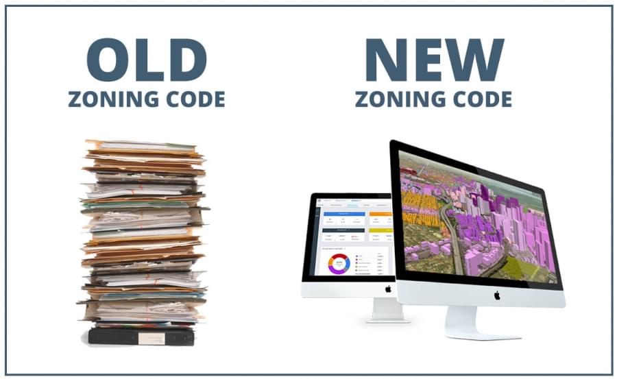
Zoning is complicated, but it shouldn’t be

Understanding the zoning of a parcel and what can be developed is difficult and usually involves hiring a land use attorney or architect, several thousand dollars and can take weeks. Land use attorneys and architects are familiar with what is often a 500+ page PDF zoning document.  They also have knowledge of all the nuances, rules, and amendments related to particular zones that can have a dramatic impact on the development potential of a site.However, their expertise is generally limited to no more than a handful of zoning codes. Experience in one particular zoning code does not guarantee that they can “breeze” through the next zoning code. Every city’s zoning code is different, in some cases drastically different.

Disrupting zoning

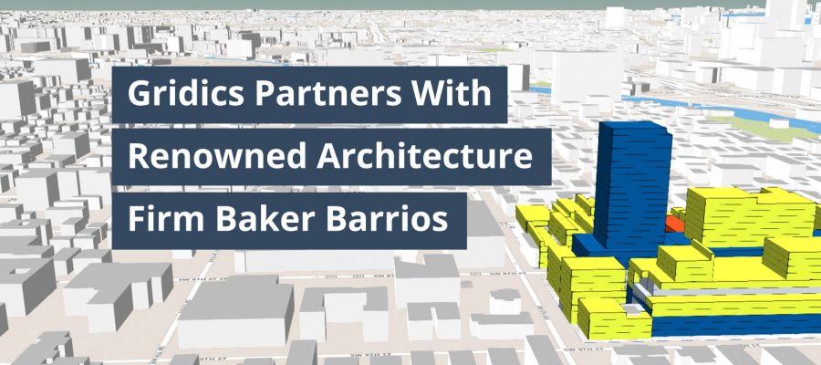
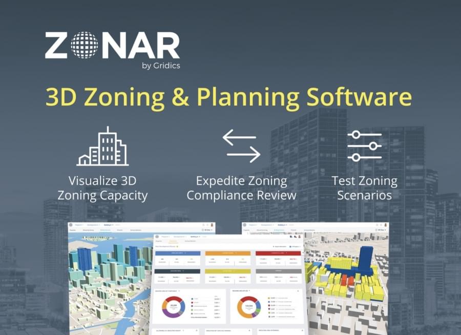
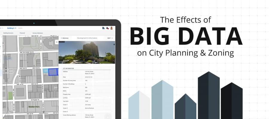
At Gridics, we developed a patent pending zoning software that at its core allows city planners to write, test, visualize and update zoning codes in real time.  In simple terms Gridics combines GIS zoning layers and parcel shapes with a city’s zoning code. We’re essentially digitizing and automating zoning codes as well as bridging the gap between the public and private sectors.

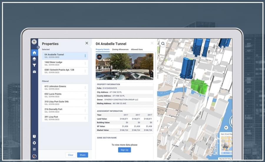
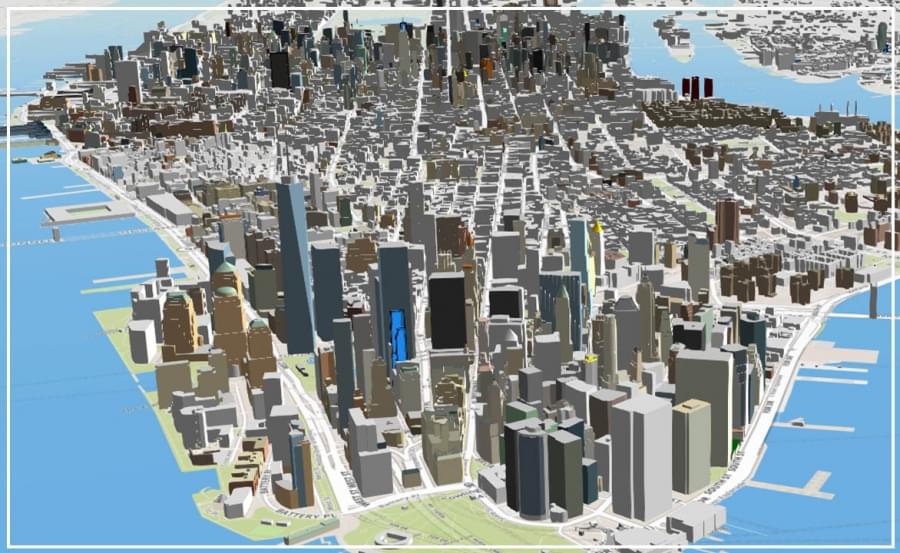
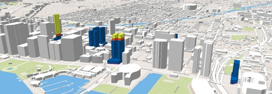
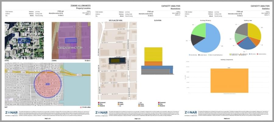
The result is that property owners and real estate professionals can click on a parcel or assemblage and quickly understand the development potential of a site in 3D. A process that normally costs thousands of dollars and weeks of analysis can now be completed with a few clicks.

How Gridics Helps Cities?

By taking advantage of our software capabilities, urban planners can:

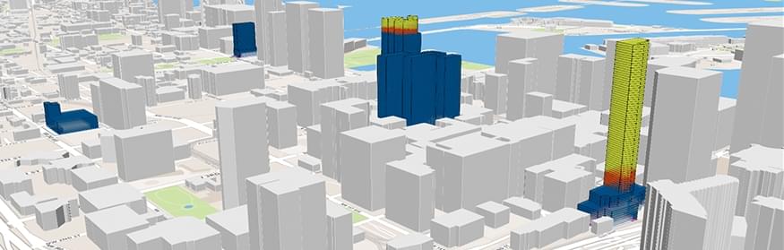
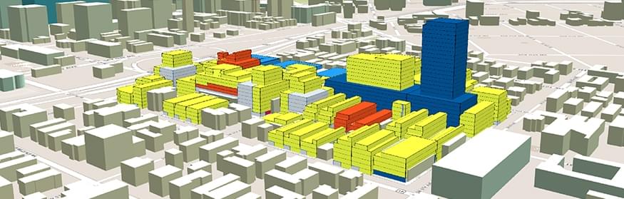
  • Visualize 3D building envelopes in real time
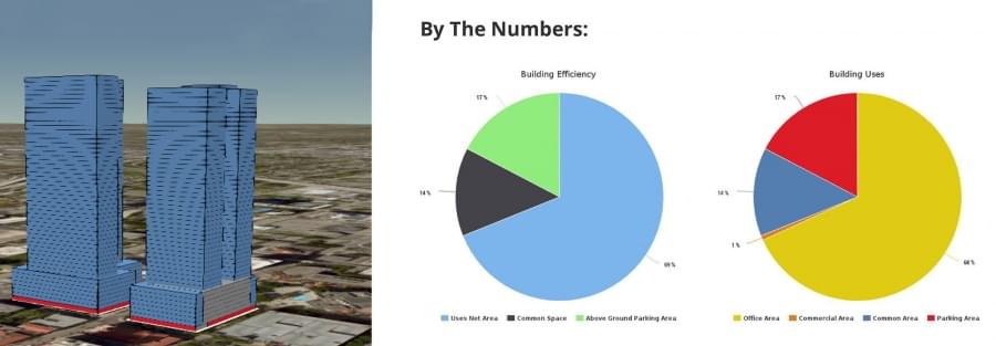
  • Analyze 3D allocation scenarios (parking, common spaces, etc.)
  • Perform weeks of zoning capacity calculations in minutes
  • Test new zoning scenarios to improve development patterns
  • Identify code conflicts and errors before problems arise
  • Conduct faster and more accurate development plan reviews
  • Reduce plan review backlog
  • Improve transparency with the public

Data Driven Decisions:

Since Gridics has all the data about the development potential of all parcels within a city, our software also allows planners to:

  • Analyze infrastructure demand (water, sewer, energy, traffic, etc.)
  • Plan for future infrastructure based on zoning capacity
  • Analyze if zoning will achieve desired transit trip generation for a TOD

The Future of Zoning Compliance

The City of Miami recently partnered with us to make the administration of zoning code compliance more efficient, faster and transparent.  The added efficiency and quality control for the zoning compliance review process that adopting Gridics will mean to cities like Miami will be a new paradigm for the use of big data. Innovative thinking that facilitates the analysis of regulatory frameworks “will allow cities to properly plan growth and align it with the best interest of the public”, says Francisco J. Garcia, Director of Planning & Zoning for the City of Miami

Scratching the surface with Gridics

We’re continuing our aggressive expansion to municipalities across the US and abroad. As this growth occurs, future iterations of the platform are simultaneously being developed to provide users with even more calculations and better visualizations, improve upload of 3D models and export capabilities, as well as analyzing infrastructure demand scenarios.

Gridics’ capability allows users to quickly test building feasibility and explore the effects of new regulations. Some features in the pipeline include a traffic module, an infrastructure module and a “back of the napkin” development cost module for developers. Architectural designs, legal lot searches or the creation of construction documents are not part of our focus. There are, however, a few interesting directions that the application will head to in the future. The use of Augmented Reality, to be able to point with a smartphone and see a site’s development potential or performing searches by development potential.

The implementation of smart strategies is usually not confined to its particular area of coverage. Benefits to city processes, improved efficiency and the ability to make more informed decisions from the adoption of innovative, transparent and easy to understand digital tools like Gridics are critical factors of city attractiveness that often turn the heads of local, national and foreign investors.

As cities become more complex and generate immense amounts of data, their zoning codes need to follow suit. The ingenuity and creativity of entrepreneurs that take on the mission to transform the zoning and planning industry is of critical importance. The job of planning departments everywhere is staggering but what seems like an impossibly complex situation has in fact given rise to the most advanced solution the zoning industry has seen since the first regulations were implemented in the early 20th century.

It’s time every city around the world catches up.

Felipe Azenha is a Gridics Co-Founder and the Director of Business Development

sales@gridics.com

305.498.9410

Video link: https://vimeo.com/191848683

Learn How Major Cities Analyze Zoning Feasibility & Reduce Plan Review Backlogs

Over the past month, we’ve hosted city governments from 25+ states on our webinars to discuss the future of 3D zoning and planning.  Major metropolitan areas like the City of Miami are already using Gridics to improve their planning department processes.

Sound like something that could be a fit for your municipality, law firm, architecture firm, or development organization?

Join us on Wednesday, July 26th at 10am OR 1pm EDT for a free 30 min. webinar:  http://webinars.zonar.city/

We’ll be giving you a behind the scenes look at the Gridics 3D zoning code management platform and covering valuable topics including how to:

  • Conduct faster & more accurate development plan reviews
  • Visualize 3D zoning capacity in real time
  • Test new zoning scenarios to improve development patterns
  • Improve transparency with the public

See you on Wednesday!

The Best Way to See How Planning Experts Are Analyzing Zoning Codes

We’re back after the holiday for two 30 min. sessions to review the future of zoning and planning.  No matter if you’re a urban planner, architect, developer, land use attorney, commercial broker, this is your chance to get ahead of the competition.

A few months ago, the City of Miami became the first global municipality to incorporate a site-specific and digitized zoning code software into their workflow.  We’re confident your organization can become just as efficient, and we want to show you how.  The future of 3D zoning and planning is here.

Join us on Tuesday, July 11th at 10am OR 1pm EDT for a free 30 min. webinar:  http://webinars.zonar.city/

We’ll be giving you a behind the scenes look at the Gridics 3D zoning management platform and covering valuable topics including how to:

  • Conduct faster & more accurate development plan reviews
  • Visualize 3D zoning capacity in real time
  • Test new zoning scenarios to improve development patterns
  • Improve transparency with the public

See you on Tuesday!